Screenshot Version. For the original, please click the link below.
Provisional Hiking Map (Papine-Holywell Jamaica), Part 2
Additional Notes
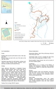
The map herein is supported with Geology & Fitness considerations to support the hiker towards experiencing a safe & fulfilling trek throughout the length of this trail. This map with support content, were developed following:
- Extensive field-data gathering by team-members of O’Shane Bryant Fitness Limited, supported by secondary surface geological map data provided by Mines & Geology Division (Jamaica).
- Remote-Sensing (satellite imagery) data-gathering of focus area, a highlight of which exists on the map herein.
- Secondary data-gathering (qualitative) from community members throughout the length of this trail.
- Fitness data-gathering (from team members of O’Shane Bryant Fitness Limited).

This map should be used as a safety & experiential resource for environmentally-sensitive hikers, and allied personnel (students, professionals, researchers…)
About The Author

Oshane Bryant: BSc Geology, Geography Minor; ACE CPT since 2012; Jamaica Business Development Corporation (JBDC) Accelerator Graduate-2018 cohort; Licensed KUKIBO Martial Arts & Self Defense, Senior Instructor; OB Fitness Founder & Managing Director.